Science
Archaeologists Expand Roman Road Network Insights by 50%
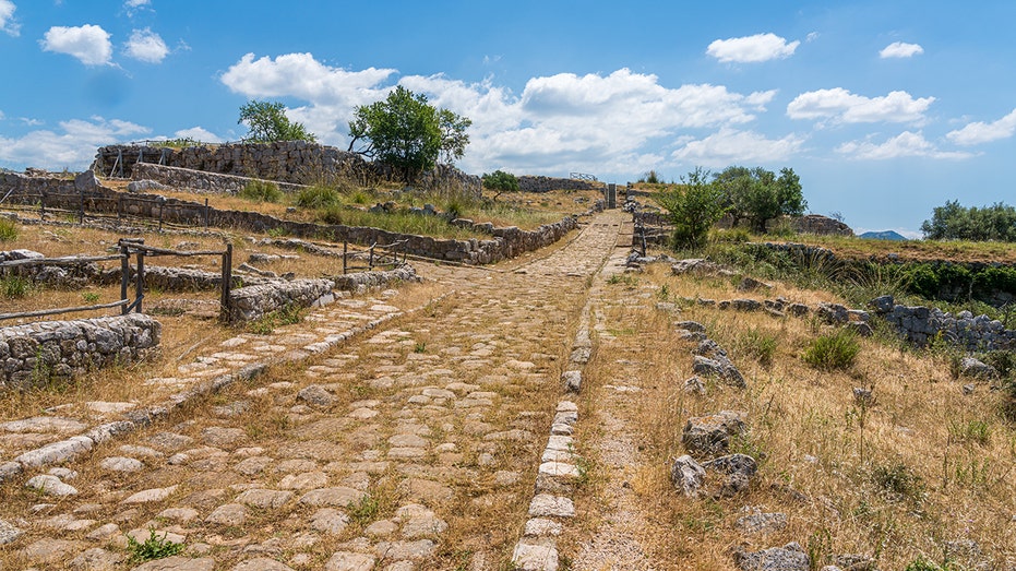
Archaeologists have significantly expanded the understanding of the Roman road network, revealing that it stretches approximately 300,000 kilometers (186,000 miles) across Europe, North Africa, and the Middle East. This new finding, published in a digital atlas called Itiner-e, represents an increase of over 100,000 kilometers compared to previous estimates.
The discovery originated from an amateur metal detectorist’s find of Roman cavalry swords in Gloucestershire. This led archaeologists to uncover a 2,000-year-old settlement, including a villa and various building remains, according to reports from Cotswold Archaeology and Historic England. The last comprehensive atlas of Roman roads was published 25 years ago and relied on incomplete records and analogue mapping techniques.
Transformative Research Techniques
Researchers utilized advanced digital methods and satellite technology to create the new atlas. Over five years, a team meticulously reviewed historical documents, ancient journals, and locations of milestones. They also analyzed satellite imagery and aerial photographs, including those digitized from World War II, to locate and trace ancient paths.
The study’s co-author, Tom Brughmans, described the process as “a massive game of connecting the dots on a continental scale.” The team examined subtle variations in vegetation, soil types, and elevation to identify where Roman roads might have been located. This comprehensive analysis allows for a more precise visualization of routes used by Roman farmers, soldiers, and diplomats.
The atlas now illustrates routes from Spain to Syria, connecting more than 5,000 ancient settlements. Previously, the extent of Roman roadways was estimated at about 188,000 kilometers (117,000 miles), primarily focusing on main highways. The new research reveals a network of secondary roads that linked villas, farms, and military outposts.
Implications for Historical Understanding
This updated mapping offers significant insights into ancient infrastructure, particularly in regions that had been previously under-documented such as North Africa, the interior plains of France, and the Peloponnese peninsula in Greece. Experts believe this foundational work will significantly contribute to future research on imperial logistics, trade networks, and cultural diffusion.
According to Benjamin Ducke of the German Archaeological Institute in Berlin, who was not involved in the project, the atlas could reshape scholarship on various historical trends. It is noted, however, that only 2% to 3% of the mapped routes have “high certainty,” indicating that clear physical traces remain, while the majority are inferred based on historical or environmental indicators.
The name Itiner-e references ancient Roman itineraria, which were travel registers listing road stations and distances. The new atlas combines historical documents with modern Geographic Information System (GIS) analysis, LiDAR, and crowdsourced archaeological data.
The data and an interactive map are freely accessible to the public at itiner-e.org, allowing users to explore these ancient routes, milestones, and settlements in detail. This interactive feature not only serves scholars and educators but also engages the broader public, enhancing understanding of ancient Roman culture and infrastructure.
As the exploration of Ancient Rome continues, recent discoveries further enrich the narrative. Recently, archaeologists uncovered a massive stone basin in the ancient ruins of Gabii, located about 11 miles east of Rome. This basin, believed to have been constructed around 250 B.C., highlights the enduring legacy of Roman engineering and architecture.
With these advancements in archaeological research and mapping, experts assert that the understanding of ancient Roman roads will continue to evolve, offering new insights into the movement of people, goods, and ideas during one of history’s most influential periods.

Salma Hayek’s Red Holiday Trend Sparks Debate Ahead of 2026

BREAKING: Shooting Sparks Collision in Orange, NJ; Children Injured

Federal Agents Pepper Spray 1-Year-Old Amid Chicago Clashes

Over 350 Flights Canceled at O’Hare Amid Ongoing Delays

Archaeologists Expand Roman Road Network Insights by 50%

Mexico Faces Rising Violence: Lessons from Colombia’s Uribe

Supreme Court Considers Future of Trump’s Tariffs and Presidential Power

Victor Oladipo Joins Wisconsin Herd in Urgent Comeback Move

Rockstar Remains Confident in GTA 6 Release Amid Delays

IROS 2025 to Showcase Cutting-Edge Robotics Innovations in China

Judge Considers Dismissal of Chelsea Housing Case Citing AI Flaws
Stone Island’s Logo Worn by Extremists Sparks Brand Dilemma

Bravo Company Veterans Honored with Bronze Medals After 56 Years

Startup Liberate Bio Secures $31 Million for Next-Gen Therapies
Arizona State University Transforms Programming Education Approach

Top Hyaluronic Acid Serums for Radiant Skin in 2025

Indonesia Suspends 27,000 Bank Accounts in Online Gambling Crackdown

Mel Kiper Jr. Reveals Top 25 Prospects for 2026 NFL Draft
-
 Science4 weeks ago
IROS 2025 to Showcase Cutting-Edge Robotics Innovations in China
-
 Politics3 weeks ago
Judge Considers Dismissal of Chelsea Housing Case Citing AI Flaws
-

 Lifestyle4 weeks ago
Stone Island’s Logo Worn by Extremists Sparks Brand Dilemma
-
 World4 weeks ago
Bravo Company Veterans Honored with Bronze Medals After 56 Years
-
 Health4 weeks ago
Startup Liberate Bio Secures $31 Million for Next-Gen Therapies
-

 Science4 weeks ago
Arizona State University Transforms Programming Education Approach
-
 Health4 weeks ago
Top Hyaluronic Acid Serums for Radiant Skin in 2025
-
 Top Stories4 weeks ago
Indonesia Suspends 27,000 Bank Accounts in Online Gambling Crackdown
-
 Sports4 weeks ago
Mel Kiper Jr. Reveals Top 25 Prospects for 2026 NFL Draft
-

 Lifestyle4 weeks ago
Mary Morgan Jackson Crowned Little Miss National Peanut Festival 2025
-

 World4 weeks ago
Honeywell Predicts Record Demand for Business Jets Over Next Decade
-

 Sports4 weeks ago
Yamamoto’s Mastery Leads Dodgers to 5-1 Victory in NLCS Game 2