Science
New Algorithm Enhances Soil Freeze-Thaw Monitoring from Space
Researchers have unveiled a new algorithm that significantly improves the ability to monitor soil freeze-thaw transitions from space. This advancement addresses longstanding challenges in capturing the dynamic nature of soil conditions, which are crucial for understanding weather patterns and hydrological cycles.
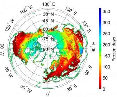
Freeze-thaw (FT) transitions in soil affect various environmental factors, including surface albedo and moisture levels. Traditionally, large-scale models have struggled to accurately represent these processes due to diurnal temperature variations and surface heterogeneity. The introduction of L-band microwave remote sensing technology offers a promising avenue for more precise monitoring as it can penetrate snow and vegetation while being sensitive to soil properties.
The existing algorithms based on the Soil Moisture Active Passive (SMAP) satellite data often rely on fixed parameters, which may not perform well across diverse land covers and climatic conditions. Recognizing these limitations, a collaborative team from Fudan University, the University of Twente, and Chengdu University of Information Technology has developed a dynamic parameter optimization algorithm to enhance soil FT detection.
The study, published on September 10, 2025, in the Journal of Remote Sensing, presents a data-driven framework that adjusts to regional variations in land cover and climate. The researchers refined the Diurnal Amplitude Variation-based Freeze-Thaw (DAV-FT) algorithm by introducing three dynamically optimized parameters—α, β, and γ. These parameters represent the detection period, variance window, and threshold sensitivity, respectively.
Using a method similar to maximum likelihood estimation, the team maximized overall classification accuracy across various regions. Their refined algorithm successfully differentiates between freezing and thawing states based on annual variations in L-band brightness temperature observed by the SMAP satellite.
The results indicate a significant increase in the regions where overall accuracy exceeded 0.7, rising from 54.43% to 89.36%. The greatest performance was noted in areas such as the Qinghai–Tibet Plateau, southwestern Eurasia, and southern North America. Additionally, the new model demonstrated high consistency with existing datasets, achieving 81.28% accuracy with the ERA5-Land dataset and 79.54% with SMAP-FT data.
Validation of the algorithm through 828 in situ soil temperature stations confirmed its superior accuracy and stability, yielding a median accuracy of 0.92. This performance surpasses that of both fixed-parameter algorithms and existing SMAP products.
“The dynamic parameter optimization significantly enhances our ability to capture subtle soil freeze-thaw transitions that vary across regions and seasons,” said Dr. Shaoning Lv, the study’s corresponding author. “By reflecting diurnal surface changes in real time, our method not only refines the retrieval accuracy of L-band data but also provides a more physically consistent understanding of land-atmosphere interactions. This represents an important step toward global-scale climate monitoring with improved temporal and spatial precision.”
The optimized DAV-FT algorithm lays a robust foundation for continuous soil freeze-thaw monitoring across diverse terrains. This advancement is particularly beneficial for climate modeling, agricultural management, and hydrological forecasting. Its ability to account for diurnal temperature cycles and regional differences makes it especially useful in high-latitude and mountainous areas where traditional algorithms face challenges.
By enhancing the accuracy of soil state detection from space, this new method strengthens the foundation for assessing permafrost dynamics, water availability, and land-atmosphere energy fluxes. These factors are crucial for predicting the impacts of climate change and improving global land-surface models.
The research received funding from the National Key R&D Program of China, the Key Research and Development and Achievement Transformation Program of Inner Mongolia Autonomous Region, the Yan Liyuan–ENSKY Foundation Project of Zhuhai Fudan Innovation Research Institute, and the National Natural Science Foundation of China.

NFL Fans Divided Over Bad Bunny’s Super Bowl Halftime Show

New Yorkers Face SNAP Benefits Freeze: Food Resources Available

TCU Safety Jamel Johnson Named Semifinalist for Jim Thorpe Award

Virginia’s Next Governor Urged to Modernize Education System

College of Engineering & Computer Science Celebrates Rankings Boost

Draymond Green Defends NBA, Commissioner Silver During Gambling Probe

Urgent: DHS Agent Shoots at Unarmed Man, Alleged Cover-Up Unfolds

Dolphins Coordinator Frank Smith Moves to Sideline, Boosts Offense

Four More Homes Collapse at Outer Banks Amid Flood Warnings

IROS 2025 to Showcase Cutting-Edge Robotics Innovations in China

Judge Considers Dismissal of Chelsea Housing Case Citing AI Flaws

Bravo Company Veterans Honored with Bronze Medals After 56 Years

Indonesia Suspends 27,000 Bank Accounts in Online Gambling Crackdown
Stone Island’s Logo Worn by Extremists Sparks Brand Dilemma

Startup Liberate Bio Secures $31 Million for Next-Gen Therapies

Mel Kiper Jr. Reveals Top 25 Prospects for 2026 NFL Draft

Top Hyaluronic Acid Serums for Radiant Skin in 2025

Honeywell Predicts Record Demand for Business Jets Over Next Decade
-
 Science2 weeks ago
IROS 2025 to Showcase Cutting-Edge Robotics Innovations in China
-
 Politics2 weeks ago
Judge Considers Dismissal of Chelsea Housing Case Citing AI Flaws
-
 World2 weeks ago
Bravo Company Veterans Honored with Bronze Medals After 56 Years
-
 Top Stories2 weeks ago
Indonesia Suspends 27,000 Bank Accounts in Online Gambling Crackdown
-

 Lifestyle2 weeks ago
Stone Island’s Logo Worn by Extremists Sparks Brand Dilemma
-
 Health2 weeks ago
Startup Liberate Bio Secures $31 Million for Next-Gen Therapies
-
 Sports2 weeks ago
Mel Kiper Jr. Reveals Top 25 Prospects for 2026 NFL Draft
-
 Health2 weeks ago
Top Hyaluronic Acid Serums for Radiant Skin in 2025
-
 World2 weeks ago
Honeywell Predicts Record Demand for Business Jets Over Next Decade
-

 Politics2 weeks ago
New Jersey Voters Urged to Register Ahead of November Election
-

 Lifestyle2 weeks ago
Mary Morgan Jackson Crowned Little Miss National Peanut Festival 2025
-

 Sports2 weeks ago
Yamamoto’s Mastery Leads Dodgers to 5-1 Victory in NLCS Game 2